Real Time Water Temperature Monitoring on the West Florida Shelf
(Use the map pins below to access plots at different stations)
Rapid intensification of tropical cyclones can be fueled by ocean warm water. Recent studies revealed that rapid intensification of Hurricane Ian (2022) could be largely related to the anomalously warm water on the West Florida Continental Shelf in the eastern Gulf of America, despite the unfavorable atmospheric conditions - high wind shears (Liu et al., 2025; Nickerson et al., 2025). In that year, the surface water was warmer than the climatology by 1 - 2 degrees Celsius, however, the subsurface water (at the 30 m level) exceeded the climatology by 2 - 3 degrees Celsius. The subsurface conditions can't be remotely sensed by satellites. It is important to monitor the water properties below the surface.
The anomalously warm water temperature on the West Florida Shelf in 2022 was related to the absence of the Loop Current impinging on the "pressure point" of the shelf (near the Dry Tortugas area) during that summer (Liu et al., 2016). Without such strong offshore forcing, upwelling of cold water from deep origin onto the shelf could not occur. Otherwise, the water on the shelf would be cooler and might not facilitate the rapid intensification of Hurricane Ian from Category 3 to 5 within 12 hours (Liu et al., 2025). Thus, coastal ocean circulation and subsurface temperature monitoring is important for future hurricane intensification forecasts.
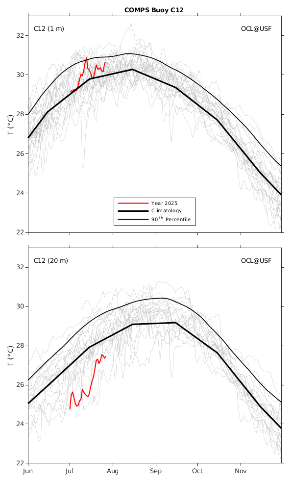
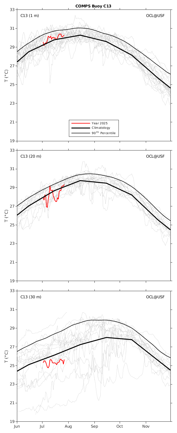
The Ocean Circulation Lab has maintained the COMPS moorings on the shelf for almost three decades. Recently, they have implemented real time monitoring of the water temperature at various levels of water column by installing sensors on the mooring chains of the two buoys (C12 and C13) on the middle shelf (around the 50 m isobath), and two buoys (C23 and C24) on the north shelf (around the 50 m isobath). The moored observations are transmitted to the lab in real time via satellites.
The daily-averaged real time water temperature data are shown (in red) along with their monthly mean climatology (thick black lines) and the 90th percentile (thin black lines), which are calculated from the long-term moored temperature data (shown as thin grey lines, one line per year for every year data was collected). Please click Buoy C12, Buoy C13, Buoy C23, and Buoy C24 for more information. The figures and calculations follow the convention in Liu et al. (2025). These subsurface temperature data provide important information on the ocean conditions and the available heat content that should be used for hurricane intensification forecasts.
The hourly-averaged real time water temperature data are also avalible for COMPS Buoy C12, Buoy C13, Buoy C23, and Buoy C24.
References:
Liu, Y., Weisberg, R.H., Sorinas, L., Law, J.A., Nickerson, A.K. (2025), Rapid intensification of Hurricane Ian in relation to anomalously warm subsurface water on the wide continental shelf, Geophysical Research Letters, 52, e2024GL113192, https://doi.org/10.1029/2024GL113192
Nickerson, A.K., Zhang, J., Weisberg, R.H., Liu, Y. (2025), Rapid intensification of Hurricane Ian (2022) in high shear, Journal of Geophysical Research Atmospheres, https://doi.org/10.1029/2024JD042024
Liu, Y., R.H. Weisberg, J.M. Lenes, L. Zheng, K. Hubbard, and J.J. Walsh (2016), Offshore forcing on the "pressure point" of the West Florida Shelf: Anomalous upwelling and its influence on harmful algal blooms, Journal of Geophysical Research Oceans, 121, 5501-5515, https://doi.org/10.1002/2016JC011938
Acknowledgements: The long-term moored observations on the West Florida Shelf have been supported through various external awards from the United States Geological Survey, the State of Florida, the Bureau of Ocean Energy Management, the Office of Naval Research, the National Oceanic and Atmospheric Administration, the National Aeronautics and Space Administration, the National Science Foundation, and the National Academies of Sciences Engineering and Medicine. Current support is primarily by Southeast Coastal Ocean Observing Regional Association (SECOORA) as a pass-through from NOAA IOOS, and supplemented by NOAA COMIT, NOAA NCCOS, State of Florida through FWC/FWRI, State of Florida Department of Environmental Protection, and Florida Flood Hub for Applied Research and Innovation. The moored observations are expanded to the northern West Florida Shelf with the funding from Florida Restore Act Center of Excellence (FLRACEP).
Disclaimer: The analyses/data are research products under development. No warranty is made, expressed or implied, regarding accuracy, or regarding the suitability for any particular application. All rights reserved: University of South Florida, College of Marine Science - Ocean Circulation Lab. Copyright, 2025.